SatRef NTRIP Services
The Survey and Mapping Office (SMO), Lands Department has implemented the NTRIP (Networked Transport of RTCM via Internet Protocol) technology for the Hong Kong Satellite Positioning Reference Station Network (SatRef) to deliver real-time services to users via the Internet. The SatRef NTRIP Services were launched on 21 June 2007. (For more information, please login to our SatRef website.)
Introduction to NTRIP |
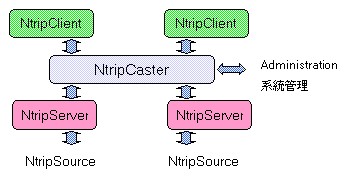
'NTRIP' is the abbreviation of 'Networked Transport of RTCM via Internet Protocol'. It is the technology of transmitting GNSS data (e.g. GNSS raw data, DGNSS corrections and Network-RTK data) to users via the Internet. With NTRIP-enabled GNSS receivers, users can simply connect the receivers to the Internet and obtain the GNSS correctional signals for positioning in higher accuracy.
It was developed by the Federal Agency for Cartography and Geodesy (BKG) of Germany, University of Dortmund and various GNSS equipment providers. It was adopted as a standard by the Special Committee No. 104 of the Radio Technical Commission for Maritime Services (RTCM-SC104) in September 2004. It is now known as RTCM 10410.0
NTRIP system allows PC, mobile devices and receivers simultaneously connecting to a broadcasting host over the Internet to get GNSS raw data and/or corrections. NTRIP technology is a common platform for delivery of GNSS data and correctional signals in real-time. For further information about NTRIP, please refer to the BKG NTRIP Homepage.